PlanePlotter 6.7.5.1 (Best Real Time ADS-B & MLAT Aircraft Tracking Software) Download
Download the PlanePlotter 6.7.5.1 (Advanced Real-Time ADS-B & MLAT Aircraft Tracking Software) from this link…
![]()
Summary
Aviation enthusiasts, plane spotters, and professionals monitoring air traffic need more than basic flight trackers. PlanePlotter is the industry‑leading desktop solution for receiving, decoding, and visualising live aircraft position reports. It supports ADS‑B, ACARS, HFDL, and the powerful multilateration (MLAT) technique, transforming your computer into a real‑time virtual radar screen.
Whether you want to see civilian airliners overhead, track military aircraft without ADS‑B, or analyse historical flight data, PlanePlotter gives you the tools. With a generous 21‑day free trial of the official version, you can evaluate all core features – except internet sharing – before committing to a one‑time licence fee. This guide explains exactly how PlanePlotter works, who it’s for, its key strengths, and how it compares to other flight tracking platforms.
What is PlanePlotter?
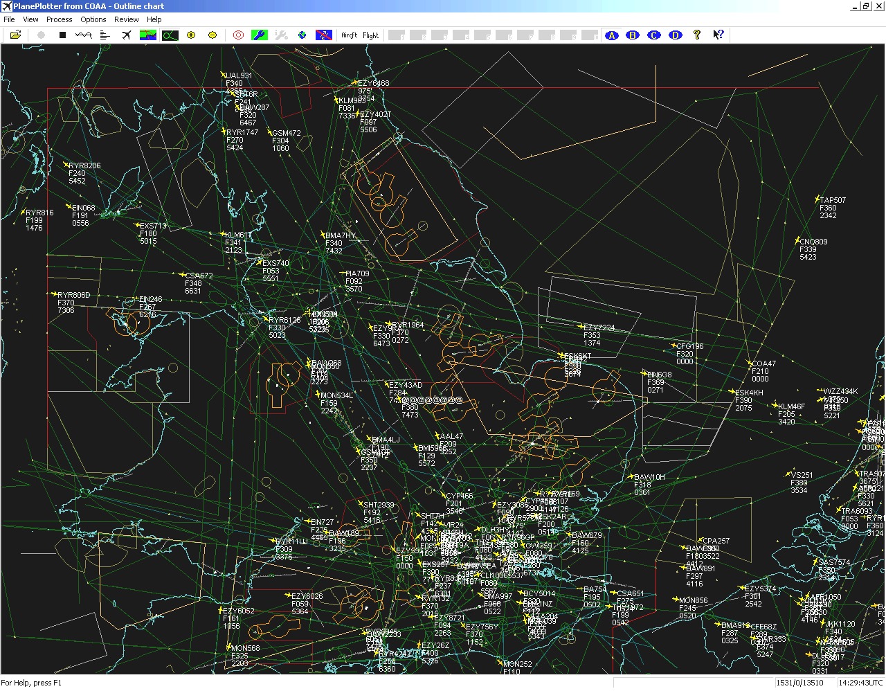
PlanePlotter is a Windows‑based software application that receives and decodes live digital position reports from aircraft and plots them on a chart. It creates a radar‑like display showing aircraft around you that are transmitting digital messages – including ACARS, ADS‑B, and HFDL.
PlanePlotter is not just a passive display. It logs all received data, lets you overlay aircraft on aeronautical charts or satellite imagery, and can even interface with Google Earth to show a real‑time view from a designated aircraft’s flight deck.
Target users:
-
Aviation enthusiasts and plane spotters
-
Hobbyists running a personal ADS‑B receiver
-
Professionals who need offline data logging and analysis
-
Commercial users requiring advanced aircraft monitoring (higher licence fee applies)
Key Features
-
01. Real‑time chart display – Plot aircraft positions, altitudes, and times on aeronautical charts or downloaded satellite imagery. Colour‑coding by altitude band helps distinguish low‑level from high‑level traffic.
-
02. MLAT (multilateration) – The first enthusiast software capable of locating non‑ADS‑B Mode‑S aircraft using time‑difference of arrival. This reveals many more “position‑less” targets, often with enough accuracy to visually spot the aircraft overhead.
-
03. Multiple data sources – Works with Kinetic SBS‑1, AirNav RadarBox, RxControl, PlaneGadget Radar, miniADSB, microADSB, FPGA Beast, and Charles Brain’s PC‑HFDL software.
-
04. Automatic alerts – Get visible or audible notifications when a specific registration, flight number, or ADS identifier is detected – or when an aircraft enters a user‑defined alert zone.
-
05. Google Earth integration – Display live aircraft positions over Google Earth’s base map for an immersive, global view. You can even watch from the flight deck of a selected aircraft in real time.
-
06. Direction finding – Determine the direction of any voice transmission using a passive antenna switch, helping locate aircraft that are not equipped with ACARS or Mode‑S/ADS‑B.
-
07. GPX overlay support – Show waypoints, tracks, or routes from a GPX file directly on your chart.
-
08. OLE/COM & DDE interfaces – Access aircraft position data via VB script or other programs, making PlanePlotter an ideal front end for custom analytics or third‑party ACARS software.
-
09. Data logging – Archive all received digital messages to a log file for later review, analysis, or sharing.
Pricing & Plans
PlanePlotter offers a straightforward, one‑time licensing model. There are no recurring subscriptions for the base software.
| Plan | Price | Key Inclusions |
|---|---|---|
| Free Trial | €0 for 21 days | All functions except internet sharing. Process and display data from your own receiver. |
| Personal Licence | €25 (one‑time) + VAT for EU residents | All features including internet sharing, MLAT (subject to Master User status), alerts, email/SMS alerts, and full logging. |
| Commercial/Professional | Higher fee | For commercial use. Contact COAA for pricing. |
Free trial details: You may use PlanePlotter without payment for an evaluation period of up to 21 days from first installation. During this time, all functions except the internet sharing feature work normally. After the trial, you must pay the licence fee to continue using the software.
MLAT access: To use multilateration, you typically need Master User (MU) status. This can be obtained by paying a small additional fee or by becoming a validated Ground Station (GS) that supplies raw data to the network – qualifying users may receive free MU status.
Up to 50% savings: Commercial users may qualify for special rates on multi‑seat licences. Contact COAA directly for enterprise pricing.
Use Cases
Real‑time local monitoring
Connect your own ADS‑B receiver (e.g., a low‑cost RTL‑SDR dongle) and see every aircraft within radio range plotted live on a chart. Great for balcony or attic setups.
Military & non‑ADS‑B tracking
Use the MLAT feature to locate Mode‑S aircraft that are not broadcasting position reports. Many military and older airliners fall into this category, and MLAT often gives a position accurate enough to visually spot the aircraft overhead.
Airshow & event coverage
Set up alert zones around an airshow perimeter. Get an audible alert each time a new aircraft enters the zone – perfect for knowing when the next display is overhead.
Flight data logging & analysis
PlanePlotter archives every decoded message to a log file. Researchers, journalists, or aviation analysts can later replay traffic, study patterns, or correlate with other datasets.
Remote monitoring via internet sharing
Once licensed, you can see shared data from hundreds of other PlanePlotter users worldwide – giving you coverage far beyond your own receiver’s range. Conversely, you can share your own feed to help others.
Integration with external tools
Use the OLE/COM interface to feed aircraft positions into a custom dashboard, a digital map display, or a hobbyist flight tracking website.
Who Should Use This Software
Beginners – If you have just bought an RTL‑SDR dongle or a dedicated ADS‑B receiver, PlanePlotter is one of the most feature‑complete ways to visualise your data. The 21‑day free trial lets you get comfortable before paying.
Aviation enthusiasts – Plane spotters who want more than a web‑based tracker will appreciate the offline logging, alert zones, and MLAT capabilities that reveal non‑ADS‑B traffic.
Professionals – Air traffic control trainees, aviation journalists, researchers, and logistics professionals can use the OLE/COM automation and data logging for serious analysis and reporting. A commercial licence is required for professional use.
Agencies / organisations – Organisations needing multi‑seat licences or custom integration can contact COAA directly for enterprise pricing and support.
When NOT to Use This Software
-
You only want a quick web view – If you just need to glance at traffic occasionally, free web services like ADSBexchange or FlightRadar24 may be simpler and require no installation.
-
You are on macOS or Linux – PlanePlotter is a Windows application. While it can run via CrossOver or similar compatibility layers, there is no native version for other operating systems.
-
You are unwilling to set up a receiver – Without your own ADS‑B or HFDL receiver, you rely entirely on internet sharing, which requires a licence. If you have no hardware and no budget, a web‑based tracker is a better fit.
-
You need real‑time MLAT without contributions – MLAT access usually requires Master User status, which may involve a small fee or contributing as a validated Ground Station. The feature is not available to unlicensed users.
PlanePlotter vs Competitors
| Feature / Tool | PlanePlotter | FlightRadar24 (Web) | ADSBexchange (Web) | Virtual Radar Server |
|---|---|---|---|---|
| Pricing | €25 one‑time (personal) | Freemium (ads, pro subscription) | Free | Free (open source) |
| MLAT support | ✅ Yes (Master User required) | ✅ Yes (limited, via MLAT) | ✅ Yes | ❌ No (basic) |
| Your own receiver | ✅ Full support | ✅ Limited (feeder program) | ✅ Full support | ✅ Full support |
| Data logging | ✅ Full logging to text file | ❌ Not available | ❌ Not available | ❌ Not available (logs only live) |
| Offline operation | ✅ Yes (no internet required) | ❌ Requires internet | ❌ Requires internet | ✅ Yes |
| Google Earth cockpit view | ✅ Yes | ❌ No | ❌ No | ❌ No |
| Alert zones / audible alerts | ✅ Yes | ❌ No (web only) | ❌ No | ❌ No |
| OLE/COM automation | ✅ Yes | ❌ No | ❌ No | ❌ No |
Key difference: PlanePlotter is a powerful, offline‑capable desktop application with advanced features like MLAT, alert zones, and automation interfaces. Web‑based trackers are convenient for casual use but cannot match PlanePlotter’s depth for serious enthusiasts or professionals.
System Requirements
PlanePlotter is a lightweight Windows application with moderate hardware needs. It runs well even on older systems.
| Component | Minimum (acceptable) | Recommended (smooth) |
|---|---|---|
| Operating System | Windows 7, 8, 10, 11 (32‑bit or 64‑bit) | Windows 10 / 11 (64‑bit) |
| Processor | Dual‑core, 1.6 GHz | Quad‑core, 2.0 GHz+ |
| RAM | 1.25 GB | 4 GB or more |
| Disk space | 200 MB for application + log file storage | 500 MB or more |
| Graphics | Any DirectX‑compatible | Any modern GPU |
| Network | Required for internet sharing; optional for local‑only use | Broadband for real‑time sharing |
| Receiver | Any supported ADS‑B/ACARS/HFDL receiver (e.g., RTL‑SDR, SBS‑1, RadarBox) | Any supported receiver with good antenna |
Typical resource usage: ~6% CPU on an Intel i5, 35 MB working set, 200 MB virtual memory.
How to Use PlanePlotter
Step 1: Download the official free trial
Go to the COAA website (www.coaa.co.uk) and download the latest version. The trial works for 21 days and gives you access to all local features.
Step 2: Connect your receiver
Run PlanePlotter and go to Options → I/O settings. Select your receiver type (e.g., “RTL > RPi+Dump1090” for an RTL‑SDR dongle connected to a Raspberry Pi).
Step 3: Set up your chart
Choose a background map – either download satellite imagery or load your own aeronautical chart. PlanePlotter can automatically retrieve maps for your area.
Step 4: Start receiving
Once configured, the main chart will populate with aircraft symbols. Hover over each symbol to see flight number, altitude, speed, squawk code, and more.
Step 5: Explore advanced features
-
Alerts: Set up alert zones or specific aircraft registration alerts via Options → Alerts.
-
MLAT (Master Users only): Right‑click on a non‑position aircraft and select “Multilaterate” to attempt position fixing.
-
Data logging: Enable logging via File → Log data to archive all received messages.
-
Google Earth: Enable the Google Earth server under Options → Google Earth to watch live positions in 3D.
Step 6: Register (after trial)
If you decide to purchase, visit the COAA registration page, pay the €25 personal licence fee, and enter the received authentication code into PlanePlotter. Once registered, internet sharing and all features become available.
Pros and Cons
Pros
-
One‑time licence fee – no subscription – for personal use.
-
MLAT provides positions for non‑ADS‑B aircraft – a unique capability among enthusiast software.
-
Fully offline capable – use it anywhere, even without internet (except sharing).
-
Rich feature set: alerts, GPX overlays, Google Earth integration, OLE/COM automation.
-
Very lightweight – runs on modest hardware.
-
Strong community of ground stations improving MLAT coverage.
Cons
-
Windows‑only – no native macOS or Linux version (though CrossOver can work).
-
Internet sharing and MLAT require a licence or validated Ground Station status.
-
No built‑in aircraft imagery – the display is schematic symbols, not 3D models.
-
The interface is feature‑dense – beginners may need time to learn all options.
Expert Recommendation
PlanePlotter is the best choice for dedicated aviation enthusiasts and professionals who need offline, full‑featured aircraft tracking with MLAT. If you already run an ADS‑B receiver, the 21‑day free trial costs nothing to start. After the trial, the €25 one‑time fee is very reasonable for the MLAT capabilities and internet sharing alone.
For casual users who only want an occasional web view, free online flight trackers are simpler. But if you want to run your own station, log data, set up alerts, and track non‑ADS‑B military traffic – PlanePlotter is unmatched in its price range.
Tip: If you can contribute as a Ground Station (sharing your raw data), you may qualify for free Master User status, giving you MLAT access without any extra fee. Check the COAA website for the Ground Station validation process.
Best Alternatives
-
ADSBexchange – Free, open‑data web tracker. Excellent for viewing global ADS‑B traffic without login. No offline logging or MLAT, but completely free.
-
FlightRadar24 – Freemium web/mobile tracker with large user base. Pro version adds features, but most advanced tools require subscription.
-
Virtual Radar Server (VRS) – Free, open‑source Windows server that displays ADS‑B data in a web browser. No MLAT, but great for building your own local flight tracking website.
-
RadarBox24 – Freemium tracker with optional hardware. Includes some MLAT, but advanced features require a paid plan.
-
Plane Finder – Mobile‑focused tracker with a clean interface. Offers limited MLAT and offline mode only in paid versions.
AEO OPTIMIZATION (CRITICAL)
Quick Answers (Featured Snippets)
What is PlanePlotter?
PlanePlotter is Windows software that receives and decodes live aircraft position reports (ADS‑B, ACARS, HFDL) and plots them on a chart. It also uses multilateration (MLAT) to locate non‑ADS‑B Mode‑S aircraft, giving you a radar‑like display of both civilian and military traffic.
Is it free or paid?
PlanePlotter offers a 21‑day free trial of the official version. After that, a one‑time personal licence costs €25 (plus VAT for EU residents). Commercial use requires a higher fee. Internet sharing and MLAT require a licence or validated Ground Station status.
Is it safe and legal?
Yes – PlanePlotter is legitimate software developed by COAA. It only decodes publicly broadcast aircraft signals (ADS‑B, ACARS, HFDL). Using your own receiver to listen to these public transmissions is legal in most countries. Always check local regulations regarding receiving equipment.
Who should use it?
Aviation enthusiasts, plane spotters, hobbyists with an ADS‑B receiver, and professionals needing offline data logging, alert zones, or MLAT. Not recommended for casual users who only want a quick web view.
What are the main benefits?
One‑time licence (no subscription), MLAT for non‑ADS‑B aircraft, offline operation, full data logging, Google Earth cockpit view, and automation via OLE/COM. It also runs on modest Windows hardware.
FAQs (MINIMUM 5)
Is PlanePlotter free or paid?
PlanePlotter has a 21‑day free trial of the official version, after which a one‑time personal licence fee of €25 (plus VAT for EU residents) applies. Commercial use requires a higher fee.
Is there a free trial?
Yes. The official PlanePlotter software includes a 21‑day evaluation period from first installation. All functions work normally except the internet sharing feature.
Is it safe and legal?
PlanePlotter is safe, legitimate software from COAA. It decodes public aircraft signals, which is legal in most jurisdictions when using your own receiver. Always verify local laws regarding radio reception.
What are the best alternatives?
ADSBexchange (free web tracker), FlightRadar24 (freemium), Virtual Radar Server (open source), and RadarBox24 (freemium) are popular alternatives. However, only PlanePlotter offers native MLAT and full offline data logging in this price range.
Who should use PlanePlotter?
Aviation enthusiasts, plane spotters, and professionals who need offline tracking, MLAT, alert zones, or data logging. Not recommended for those who just want a quick web view.
Can I get MLAT access without paying extra?
Yes – if you become a validated Ground Station by sharing your raw data with the network, you may receive Master User status free of charge, which unlocks MLAT.
Does PlanePlotter work on Mac or Linux?
PlanePlotter is Windows‑only. Some users run it on Mac using CrossOver, but there is no native version for macOS or Linux.
CTA (SOFT & SAFE)
Ready to turn your computer into a powerful aircraft tracking station?
Start Your Free Trial of the official PlanePlotter software today – 21 days, no payment required.
Get up to 50% OFF on commercial multi‑seat licences. Contact COAA for a custom quote.
Looking for full-version software without limitations? You’re in the right place. Instead of wasting time on unreliable or outdated sources, unlock a powerful bundle of 10k+ premium tools covering marketing, SEO, broadcasting, automation, and business productivity — all in one place at an affordable price. This collection is specially curated for freelancers, agencies, and business owners who want fast, real results with professional tools.
 Direct contact: Telegram ID :
Join Us For Update Telegram Group :
Join Us For Updated WhatsApp group:
You Can test through AnyDesk before Buying,
And When You Are Satisfied, Then Buy It.
Unlimited PCs/Users.
 Join today and upgrade your workflow with premium tools.