GeoLogismiki Suite 2025 (Comprehensive Software for Geotechnical Analysis) Download
Download the GeoLogismiki Suite 2025 (Comprehensive Software for Geotechnical Analysis) from this link…
![]()
Summary
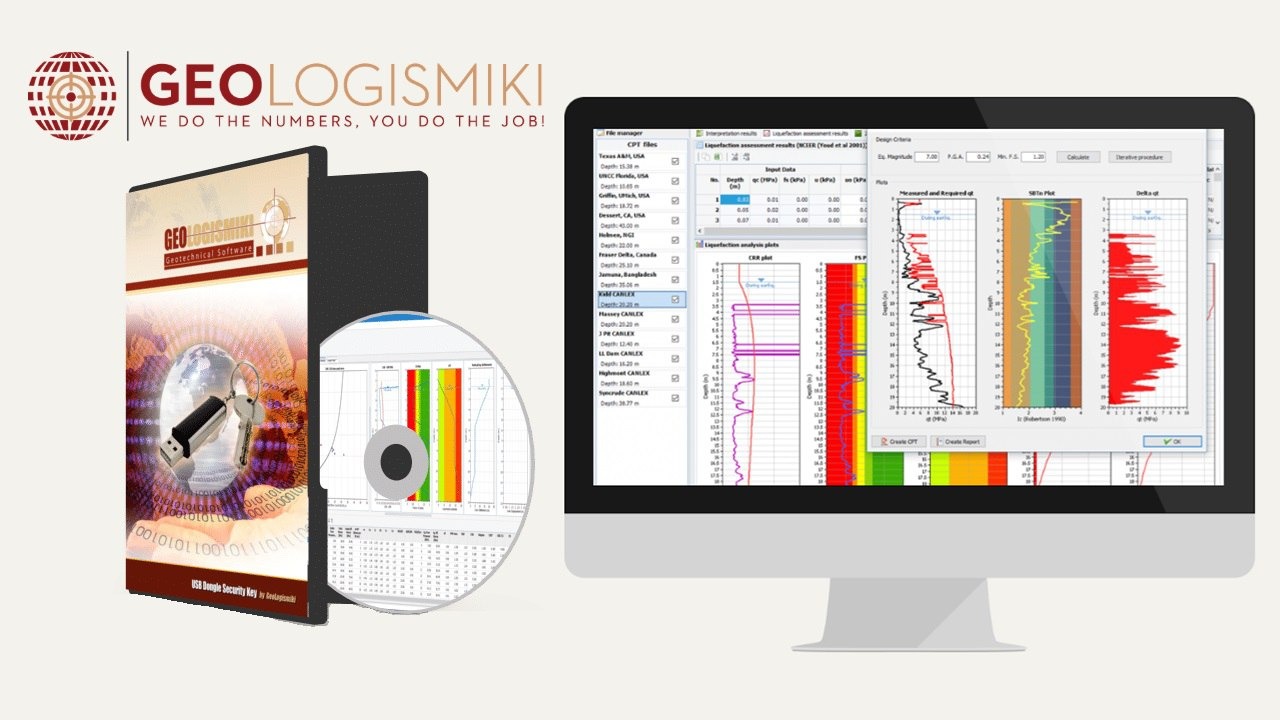
GeoLogismiki Suite provides specialized tools for Geotechnical engineers, designed to handle complex tasks from borehole logs to assessing soil liquefaction. Based in Greece, GeoLogismiki develops Software for geologists, engineers, and environmental professionals, helping them visualize boreholes, create stratigraphic columns, monitor groundwater levels, and analyze soil and rock data. The suite includes powerful modules like CLiq, StoneC, CPeT-IT, BLogPro, LiqSVs, SectionMaker, SPAS 2019, SPTCorr, SteinN Pro, and SteinP 3DT, each tailored for specific geotechnical tasks.
The suite emphasizes user-friendly interfaces, robust performance, and precise analysis, allowing engineers to create detailed reports, assess foundation settlements, evaluate soil improvement, and perform cone penetration tests (CPT) with confidence. Integrating advanced visualization tools such as TeeChart, GeoLogismiki ensures engineers have interactive charts, synchronized logs, and clear 2D/3D visualizations, streamlining the entire workflow and supporting efficient, reliable decision-making.
Specialized Modules for Geotechnical Applications
CLiq is designed to evaluate soil liquefaction from CPT data, while StoneC implements the Priebe Method to estimate soil improvement with stone columns. CPeT-IT provides a powerful, intuitive interface to interpret and present cone penetration tests, incorporating Dr. Peter Robertson’s expertise. BLogPro allows for the creation of detailed borehole data sheets, supporting stratigraphic and technical data. LiqSVs uses SPT and shear wave tests for accurate liquefaction assessment, while SectionMaker creates precise 2D cross-sections for enhanced visualization. SPAS 2019 and SPTCorr analyze seismic waves and soil mechanical parameters, ensuring comprehensive geotechnical analysis. SteinN Pro and SteinP 3DT provide settlement calculations under various foundations, supporting both 2D and 3D analyses.
Intuitive User Experience and Technical Support
Engineers appreciate the intuitive design and ease of use of GeoLogismiki Suite. Technical support is responsive, ensuring any issues with modules are promptly addressed. The software is trusted by professionals worldwide, providing consistent updates and tools that enhance everyday geotechnical practice. Whether creating CPT reports, assessing liquefaction risks, or generating stratigraphic logs, the modules simplify tasks while maintaining high precision. User feedback directly informs updates, creating a continuous improvement cycle that strengthens reliability.
New Licensing Models and Accessibility
GeoLogismiki has introduced new license types to make activation and tracking easier. Individual modules can be purchased according to specific project needs, ensuring cost-effective solutions for firms of all sizes. Webinars, guides, and tutorials are available to provide comprehensive learning, enabling engineers to quickly adapt to the software. Multilingual support ensures accessibility for a global audience, allowing professionals from different countries to work seamlessly without language barriers.
Advanced Data Visualization with TeeChart
TeeChart Pro VCL/FMX forms the visual backbone of GeoLogismiki Suite. Engineers can visualize borehole logs, stratigraphy, environmental data, and statistical analyses through interactive, synchronized charts. Features include multi-track vertical charts for lithology, time-series plots for groundwater monitoring, histograms, scatter plots, box plots, and 2D/3D contour maps. These visual tools enhance the clarity of reports, streamline decision-making, and support precise interpretation of complex geotechnical data.
Workflow Optimization and Reporting
The combination of GeoLogismiki Suite and TeeChart enhances workflow efficiency. Engineers can upload borehole and lab data, process intervals, and generate synchronized logs. With one click, charts can be exported as high-resolution vector graphics for final reporting. The automated yet flexible workflow ensures engineers deliver precise results while minimizing manual effort, allowing focus on critical analysis and design. This robust pipeline supports foundation analysis, soil risk assessment, and CPT interpretation efficiently.
Global Reach and Community Support
GeoLogismiki Suite has achieved worldwide adoption. Professionals in Europe, the Middle East, Asia, and the Americas rely on the suite for critical geotechnical tasks. Online webinars, tutorials, and technical guides foster a collaborative learning environment. By integrating feedback from engineers and geologists globally, the software continues to evolve, providing relevant, real-world solutions for diverse geotechnical challenges. Users are encouraged to share knowledge, further enhancing the professional community.
Engineering Precision and Future-Proofing
GeoLogismiki ensures accuracy and reliability through continuous updates and integration with proven libraries. The use of TeeChart guarantees consistency across modules, whether for liquefaction assessment, settlement calculations, or borehole visualization. The software is scalable, supporting 3D visualizations, GIS overlays, and interactive dashboards, preparing engineers for future challenges. Its robust architecture ensures long-term usability and adaptability in evolving geotechnical projects.
Comprehensive Geotechnical Analysis
From CPT interpretation to foundation settlements, liquefaction evaluation, and soil improvement, GeoLogismiki Suite provides a complete geotechnical solution. Engineers can make informed decisions, backed by precise data, interactive visualizations, and structured reporting. By leveraging this suite, geotechnical professionals enhance the safety, efficiency, and reliability of infrastructure projects, transforming complex data into actionable insights.
Specialized CPT-Based Liquefaction Analysis
GeoLogismiki is a newly founded software company specializing in geotechnical engineering software for everyday practice. They are pleased to announce the availability of CLiq, a new Cone Penetration Test (CPT) based liquefaction analysis software. The software includes a unique 2D feature that enables the creation of colorful contour maps showing the overall liquefaction potential index (LPI) and post-earthquake vertical settlements in plan view, allowing users to visualize the spatial variation of liquefaction potential and settlements across a site.
Parametric Analysis and 3D Visualization
A parametric analysis feature allows engineers to vary earthquake magnitude and surface acceleration to evaluate the sensitivity of both the overall liquefaction potential index and post-earthquake settlements. Results are presented in a 3D graphical form, providing a clear understanding of how earthquake loading impacts a site. This functionality also allows engineers to estimate differential settlements for a given site and design earthquake, supporting more accurate and safe geotechnical design decisions.
Data Export and Accessibility
As with all GeoLogismiki software, all input and output data can be exported to Microsoft® Excel for further manipulation and reporting. This ensures that engineers can easily integrate CLiq results into their existing workflows and perform additional analyses as needed. Whether you are a current LiqIT registered user or a new user searching for a CPT liquefaction analysis software, GeoLogismiki strongly encourages you to try CLiq and experience its powerful features for geotechnical practice.
Our Paid Service
If you want to Purchase Cracked Version / KeyGen Activator /License Key
Contact Us on our Telegram ID :
Join Us For Update Telegram Group :
Join Us For Update WhatsApp group:
Crack Software Policies & Rules:
Lifetime Activation, Unlimited PCs/Users,
You Can test through AnyDesk before Buying,
And When You Are Satisfied, Then Buy It.